Showing results 1781 to 1790 of 2394
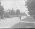
Museum Ref No: AH_Poole_Road_BroadstonePostcard caption "Pool Road, Broadstone"
From the Andrew Hawkes collection.
Photograph
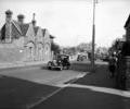
Museum Ref No: Batting/Box 2/Poole Carnival/No.3Poole Road/Ashley Road, Branksome. Sharp Jones Pottery buildings on left. (Batting photograph)
Photograph
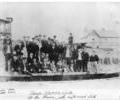
Museum Ref No: G8e_0001Poole Rowing Club at the Haven, Sandbanks.
From the Ernest Bristowe collection.
Photograph
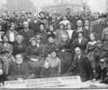
Museum Ref No: AH_Poole_Soliders_Home_Committee_BroadstonePostcard of Poole Soliders Home Committee.
From the Andrew Hawkes collection.
Photograph
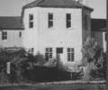
Museum Ref No: E8d_0001Union Workhouse, Longfleet. Exterior view of part of building with cupola c.1980-1989.
Photograph
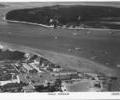
Museum Ref No: AH_Poole_Harbour_Yacht_CompanyPostcard of Poole Yacht Company with Brownsea Island in the background. Pan-Aero Pictures, Kingston on Thames.
From the Andrew Hawkes collection. For commercial use please contact the copyright holder.
Photograph
Museum Ref No: PLA 942.337Poole, Town and Harbour by Richard Blomfield, published by Dorset Publishing Company, 1989. Illus. ISBN 0 948699 14 0
Book
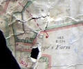
Museum Ref No: VM_XLIV5_PopesFmPope's Farm, Fleets Corner.
Detail of Ordnance Survey Dorset Sheet XLIV.5 scale 1:2500 1900 Revision with valuation annotations AC
Map
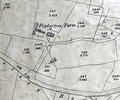
Museum Ref No: VM_XLIV9PoplartreePoplartree Farm, Oakdale, btwn Cemetery and Darby's Lane
Detail of Ordnance Survey Dorset sheet XLIV.9 scale 1:2500 1900 revision with valuation annotations AC
Map
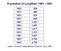
Museum Ref No: PLA 942.33Population of the Tything of Longfleet for the years 1801 to 1901. Source: Victoria History of the Counties of England; a History of Dorset, vol 2, 1908
Book