Showing results 1 to 6 of 6
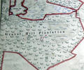
Museum Ref No: VM_XXXV13GravelHillPlantationGravel Hill Plantation, either side of Blackwater Drive
Ordnance Survey Dorset Sheet XXX1V.13 scale 1:2500 1900 revision with valuation annotations AC
Map
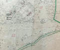
Museum Ref No: rVM_SheetXXXIV.12_HigherMerleyFarmHigher Merley Farm, Pond Coppice, Merley Pond and Merley House
Detail of Ordnance Survey Dorset Sheet XXXIV.12,1:2500 scale, 1900 revision with valuation annotations AC
Map
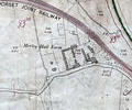
Museum Ref No: rVM_XXXIV12_ MerleyHallFarmMerley Hall Farm, Dawson's Hole and Northern edge of Municipal boundary.
Detail of Ordnance Survey Dorset Sheet XXXIV.12, 1:2500 scale, 1900 revision with valuation annotations AC
Map
Museum Ref No: PLA 942.337History of the Borough and County of the Town of Poole by H. P. Smith, Poole, J. Looker Ltd., vol. 1 1948. Illus. Pages 41-42.
Book
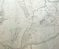
Museum Ref No: rVM_SheetXXXIV.12_MerleyHouseAndCoppicesMerley House and adjacent coppices
Detail of Ordnance Survey Dorset Sheet XXXIV.12, 1:2500 scale, 1900 revision with valuation annotations. AC
Map
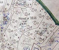
Museum Ref No: VM_XXXV.13StoatsHillStoats Hill, between Brake Hills and Canford Sports Arena
Detail of Ordnance Survey Dorset Sheet XXXV.13 scale 1:2500 1900 revision with Valuation annotations AC
Map