Showing results 1 to 10 of 25
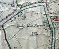
Museum Ref No: VM_XLIV.13_BlakeHillFarmBlake Hill Farm, between Elgin Road and Compton Avenue.
Detail of Ordnance Survey Dorset Sheet XLIV.13 scale 1:2500 1900 revision with valuation annotations AC
Map
Museum Ref No: AH_Farmhand_Stock_front_castleFarmhand and stock in front of Brownsea Castle. From the Andrew Hawkes collection.
For commercial use please contact Andrew Hawkes by email: hawkes99@gmail.com
Photograph
Museum Ref No: AH_Farmhand_castle_backdropFarmhand with Brownsea Castle as backdrop. From the Andrew Hawkes collection.
For commercial use please contact Andrew Hawkes by email: hawkes99@gmail.com
Photograph
Museum Ref No: rVM_SheetXLIII.8_BushelsMillFarmBushels Mill Farm
Detail of Ordnance Survey Dorset Sheet XL.lll.8 scale 1:2500 1900 revision, with valuation annotations. AC
Map
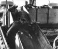
Museum Ref No: Bristowe2_252Cattle being unloaded from "Steintjemensinga", 1957.
From the Ernest Bristowe collection.
Photograph
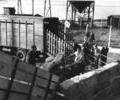
Museum Ref No: Bristowe2_251Cattle being transferred from a livestock transport to a boat.
From the Ernest Bristowe collection.
Photograph
Museum Ref No: rVM_XLIII.8_CreekmoorFarmBridgeMillCreekmoor Farm, Mill & Bridge
Detail of Ordnance Survey Dorset Sheet XLIII.8 scale 1:2500 1900 revision, with valuation annotations. AC
Map
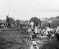
Museum Ref No: F6d_0007Gathering seaweed for fertiliser; men, women, and children on seashore with horse-drawn carts, 1870-1900
Photograph
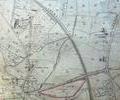
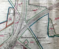
Museum Ref No: rVM_XLIII.11_HamworthyJunction&TurlinMoorHamworthy Junction, Junction Hotel, Bennetts Place, Vineyard Copse, The Grove, Turling Moor House, Yarells Farm, Windmill.
Detail of Ordnance Survey Dorset Sheet XLIII.11, 1:2500 scale,1900 edition with annotations AC
Map
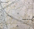
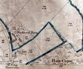
Museum Ref No: rVM_XLIII.12_HarkwoodFmHarkwood Farm and Ham Copse
Detail of Ordnance Survey Dorset, sheet XLIII.12 scale 1:2500 1900 revision with valuation annotations. AC
Map