Showing results 1 to 10 of 46
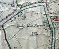
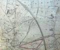
Museum Ref No: VM_XLIV.13_BlakeHillFarmBlake Hill Farm, between Elgin Road and Compton Avenue.
Detail of Ordnance Survey Dorset Sheet XLIV.13 scale 1:2500 1900 revision with valuation annotations AC
Map
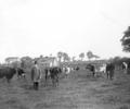
Museum Ref No: F6d_0006Two men standing in field with cows; one wearing top hat, building in background; lane and gaslamp on right hand side; written underneath "Brown's Farm, Wimborne Road, 1880", 1880
Photograph
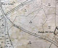
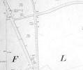
Museum Ref No: rVM_SheetXLIII.8_BushelsMillFarmBushels Mill Farm
Detail of Ordnance Survey Dorset Sheet XL.lll.8 scale 1:2500 1900 revision, with valuation annotations. AC
Map
Museum Ref No: F6d_0017Clapper Farm, Longfleet; looking up at two-storey house; postcard which is postmarked 12.5.1909, adressed to Mr. and Mrs. Wetton, 134 Ashley Road, Upper Parkstone, 1890-1910
Photograph
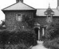
Museum Ref No: F6d_0016Clapper Farm, Longfleet; looking up path towards two-storey house; postcard which is postmarked 23.12.1908; addressed to Mr. and Mrs. Wetton, 134 Ashley Road, Upper Parkstone, 1890-1910
Photograph
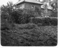
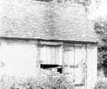
Museum Ref No: F6d_0015Clapper Farm, Longfleet; barn behind farm; brick building with tiled roof; one of doors blocked by piled up bricks, 1890-1910
Photograph
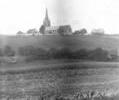
Museum Ref No: F6d_0014Clapper Farm, Longfleet; view across fields to St. Mary's Church, Longfleet, and school, 1890-1910
Photograph
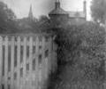
Museum Ref No: F6d_0013Clapper Farm, Longfleet; two-storey house; front gate in foreground; Longfleet Church spire in background, 1890-1910
Photograph
Museum Ref No: rVM_XLIII.8_CreekmoorFarmBridgeMillCreekmoor Farm, Mill & Bridge
Detail of Ordnance Survey Dorset Sheet XLIII.8 scale 1:2500 1900 revision, with valuation annotations. AC
Map
Extract from Ordnance Survey XL1V.9, 1902. Showing Darbys Lane and Henning's Farm
Map