Showing results 71 to 75 of 75
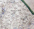
Museum Ref No: VM_XXXV.13StoatsHillStoats Hill, between Brake Hills and Canford Sports Arena
Detail of Ordnance Survey Dorset Sheet XXXV.13 scale 1:2500 1900 revision with Valuation annotations AC
Map
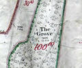
Museum Ref No: VM_XLIII.II_theGroveThe Grove, NE of Hamworthy.
Detail of Ordnance Survey Dorset Sheet XLlll.II 1900 revision scale 1:2500, with valuation annotations. AC
Map
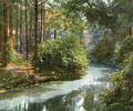
Museum Ref No: AH_The_Lakes_BranksomePostcard, Victoria Series.
Copyright: John Davies, 24 Queen Victoria Street, E. C.
From the Andrew Hawkes collection.
Photograph
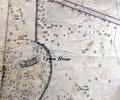
Museum Ref No: rVM_SheetXLIII.8_UptonHouseUpton House and Northmead Copse.
Detail of Ordnance Survey Dorset Sheet XL111.8 scale 1:2500 1900 revision with valuation annotations. AC
Map
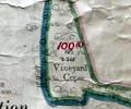
Museum Ref No: VM_XLIII.II_VineydCopseVineyard Copse, Symes Rd, Hamworthy.
Detail of Ordnance Survey Sheet XLlll:ll scale 1:2500 1900 revision with valuation annotations. AC
Map