Showing results 401 to 410 of 709
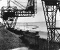
Museum Ref No: B5a_007Fisherman's Dock seen through the coal gantries,1936.
From the Ernest Bristowe collection.
Photograph
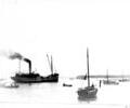
Museum Ref No: Bristowe2_130The fishing fleet was moored on both sides of the channel from Gasworks Quay to Stokes Bay, during 1922 Harbour development. A gasworks coal transporter leaving light.
From the Ernest Bristowe collection.
Photograph
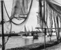
Museum Ref No: B4d_0012Fishing nets drying at Fisherman's Dock, fishing boat; Hamworthy Quay in background, c.1946.
From the Ernest Bristowe collection.
Photograph
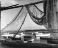
Museum Ref No: B4d_0001Fishing nets drying at Fisherman's Dock and fishing boats at moorings; Brownsea Island in the background, c.1950-1969.
From the Ernest Bristowe collection.
Photograph
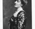
Museum Ref No: AH_Florence_van_RaaltePrint of Florence Van Raalte, wife of Charles Van Raalte, former owner of Brownsea Island.
From the Andrew Hawkes collection. For commercial use please contact Andrew Hawkes by email: hawkes99@gmail.com
Photograph
Museum Ref No: PLA 9 BROFor Nature Not Humans by Peter Moore. Mrs Bonham Christie and Brownsea Island, published by Poole Historical Trust, 2003. Illus. ISBN 187353545 7
Book
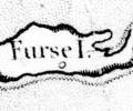
1785 survey, Mackenzie. Chart of Furse Island
Map
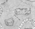
1849 chart, Sheringham
Map
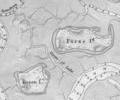
1902 Admiralty survey, Sheringham
Map
1910 chart, Simpson,Jones,Shaw,Kennedy,Rice
Map