Showing results 451 to 460 of 709
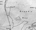
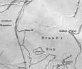
1910 chart, Simpson,Jones,Shaw,Kennedy,Rice
Map
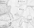
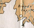
1912 chart, H.E.Purey-Cust
Map
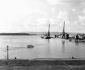
Museum Ref No: Bristowe1_13Hamworthy Boat Dock. Boats moored for the loading of cargo. Brownsea Island in the distance.
From the Ernest Bristowe collection
Photograph
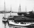
Museum Ref No: Bristowe2_6Boats Moored at Hamworthy Quay with men working aboard.Poole Quay seen to the left with Poole Pottery kilns and Gas Works coal transporter in the distance.
From the Ernest Bristowe collection.
Photograph
Museum Ref No: PLA 942.337History of the Town and County of Poole by John Sydenham, Poole, Sydenham, 1839 Pages 376-383
Book
Museum Ref No: PLA 942.337History of the Town and County of Poole by John Sydenham, Poole, Sydenham, 1839 Pages 371-375
Book
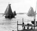
Museum Ref No: Batting/Box 3/Poole Harbour/No.2Yachts sailing through Harbour entrance. Shell Bay ferry jetty in foreground. (Batting photograph)
Photograph
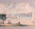
Museum Ref No: AH_Harbour_Entrance_and_BrownseaPostcard (unidentified original), looking across to Brownsea Island.
From the Andrew Hawkes collection. For commercial use please contact Andrew Hawkes by email: hawkes99@gmail.com
Picture