Showing results 5821 to 5830 of 6433
Extract from Borough Engineer's Plan 1952
Map
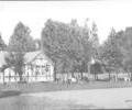
Museum Ref No: B6a_0124The old Tea House in Poole Park, adjacent to the cricket pitch.
Photograph
Teesdale Private Hotel.
De Maulley Road, Canford Cliffs.
Tel 1163.
Picture
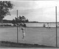
Museum Ref No: B6a_0085People playing tennis in Poole Park, c.1960's.
Photograph
Museum Ref No: B6a_0009People Playing tennis in Poole Park, c.1900.
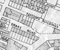
Extract from Ordnance Survey XL111.16
Map
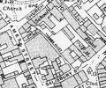
Extract from Ordnance Survey XL111.16
Map
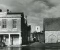
Museum Ref No: Bristowe1_142Thames Street Viewed from the Quay, 1948. St. James' Church can be seen in the middle distance. Harbour Office near left and Town Cellars near right.
From the Ernest Bristowe collection.
Photograph
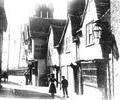
Museum Ref No: D_Thames_Street_0038Thames Street. New Inn (later the King Charles Inn). Houses with bracket lamp.
Photograph
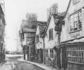
Museum Ref No: D_Thames_Street_0036Thames Street, artistic impression? New Inn.
Photograph