Showing results 711 to 720 of 747
Street index to historical maps and charts of the Poole area.
Map
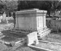
Museum Ref No: BEAM_0073Styring family tomb, Garland Cemetery.
Undated.
B/W photograph.
JPBC
Photograph
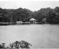
Museum Ref No: AH_SummerhouseFrom the Andrew Hawkes collection.
For commercial use please contact Andrew Hawkes by email: hawkes99@gmail.com
Photograph
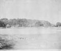
Museum Ref No: AH_Summer_House_BrownseaFrom the Andrew Hawkes collection.
For commercial use please contact Andrew Hawkes by email: hawkes99@gmail.com
Photograph
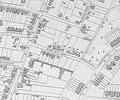
Extract from Ordnance Survey XL1V.10
Map
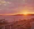
Museum Ref No: AH_Sunset_at_SandbanksPostcard. Picture of the sunset across Poole Harbour seen from the Haven Hotel, with Brownsea in the background.
Postcard Plastichrome by Colourpicture.
From the Andrew Hawkes collection. For commercial use please contact the copyright holder.
Photograph
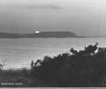
Museum Ref No: AH_Sunset_over_Brownsea_IslandPostcard entitled Sunset over Brownsea Island, 5282. Judges Ltd of Hastings.
From the Andrew Hawkes collection. For commercial use please contact the copyright holder.
Photograph
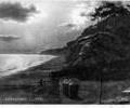
Museum Ref No: AH_Sunset_Branksome_CliffsPostcard reads "Sunset, Branksome Cliffs".
Franked 31st August 1918.
From the Andrew Hawkes collection.
Photograph
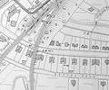
Extract from Ordnance Survey XL1V.10
Map
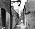
Museum Ref No: D_Swan_Alley_0002Swan Alley, 1957. Bracket lamp and central gutter. Photograph Barbara Bristowe.
Photograph