Showing results 1861 to 1870 of 1873
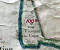
Museum Ref No: VM_XLIII.II_VineydCopseVineyard Copse, Symes Rd, Hamworthy.
Detail of Ordnance Survey Sheet XLlll:ll scale 1:2500 1900 revision with valuation annotations. AC
Map
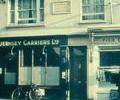
Museum Ref No: D_High_Street_0057sHigh Street, Nos.41-43. Showing Guernsey Carriers Ltd and Charles II and Duke of Monmouth plaque.
Photograph
Water Tower, Water Tower Lane Broadstone
Description Taken from Poole Listed Buildings
Factfile
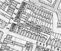
Extract from Borough Engineer's Plan 1952
Map
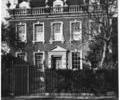
Museum Ref No: E1b_0008West End House, corner of Thames Street and West Street.
From the Ernest Bristowe collection.
Photograph
West Quay Road (Eastside) Nos 10 To 13
Description taken from Poole Listed Buildings
Factfile
West Quay Road (Nos 10 to 13)
Description taken from Poole Listed Buildings
Factfile
West Quay Road (Westside) Gate Piers Ajacent to Electricity Sub Station Opposite No 12
Description taken from Poole Listed Buildings
Factfile
West Street (Westside) No 32
Description taken from Poole Listed Buildings
Factfile
West Street (westside) Nos 1 To 4
Factfile