Poole History Online is a free online database of photographs, documents and data relating to the local history of the Borough of Poole. This website is managed by Poole Museum and updated by staff and volunteers. Find out more
about this site.
If you experience any problems, please see the
help page.
Showing results 41 to 50 of 54
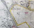
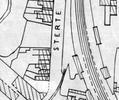
Museum Ref No: rVM_XLIII.12SterteHse&TatnamFmSterte House, Tatnam Farm and Holes Bay Junction.
Detail of Ordnance Survey Dorset Sheet XLIII.12 scale 1:2500 1900 revision with valuation annotations. AC
Map
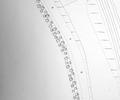
Extract from Ordnance Survey 12.25
Map
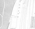
Extract from Ordnance Survey 16.5
Map
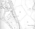
Extract from Ordnance Survey XL111.12 1902
Map
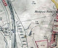
Museum Ref No: rVM_XLIII.12_SterteLodgeHeckfordFmSterte Lodge and Heckford Farm.
Detail of Ordnance Survey Dorset Sheet XL.III.12 scale 1:2500 1900 revision with valuation annotations. AC
Map
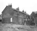
Museum Ref No: C_Sterte_0015Sterte; 5-15 Sterte Road. Rear elevations.
Photograph
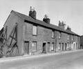
Museum Ref No: C_Sterte_0014Sterte; 5-15 Sterte Road. Front elevations.
Photograph
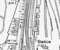
Extract from Ordnance Survey XL111.16
Map
Extract from Borough Engineer's Plan 1952
Map
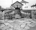
Museum Ref No: C_Sterte_0011Sterte; Fountain erected in 1950s on site of old spring.
Photograph