Showing results 21 to 30 of 46
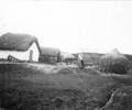
Museum Ref No: Coney album 2 photograph 45Lake Farm, Hamworthy. (Coney photograph)
Photograph
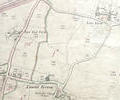
Museum Ref No: rVM_XXXIV.12_LambsGreenAndFarmsLamb's Green, Lake Farm, East End Farm and Methodist Chapel
Detail of Ordnance Survey Sheet XXXIV.12, 1:2500 scale, 1900 revision with valuation annotations AC
Map
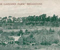
Museum Ref No: AH_Lavender_Farm_BroadstonePostcard reads "At The Lavender Farm, Broadstone".
There is an article on the Lavender farm by Olive Knott in the Dorset Year Book 1956-57 pages 60-62 which includes a photo of the interior of this factory. The article states that this building was later converted into the headquarters of the Broadstone Athletics Association, but in 1935 it was burnt to the ground.
From the Andrew Hawkes collection.
Photograph
Museum Ref No: rVM_XXXIV12_ MerleyHallFarmMerley Hall Farm, Dawson's Hole and Northern edge of Municipal boundary.
Detail of Ordnance Survey Dorset Sheet XXXIV.12, 1:2500 scale, 1900 revision with valuation annotations AC
Map
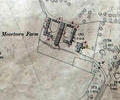
Museum Ref No: VM_XXXV9_MoortownFarmMoortown Farm, off Moortown Drive.
Detail of Ordnance Survey Dorset Sheet XXXV.9 scale 1:2500 1900 revision with valuation annotations AC
Map
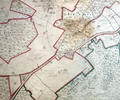
Museum Ref No: rVM_XXXV.13_NewtownFarmNewtown Farm, Big Covert, Pennington Covert, Arrowsmith Coppice, Long Coppice, Gravel Hill Plantation
Map
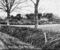
Museum Ref No: AH_ Broadstone_From_Plain_FieldPostcard reads "Broadstone from Plain Field". Dated 24.12.1908.
Copyright: L. French, Broadstone.
From the Andrew Hawkes collection.
Photograph
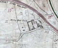
Museum Ref No: rVM-XXXIV.12_PlainfieldFmPlainfield Farm & Darbys Corner. Detail of Ordnance Survey Dorset Sheet XLIII.4, 1:2500 scale, 1900 edition with valuation annotations. AC
Map
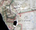
Museum Ref No: VM_XLIV5_PopesFmPope's Farm, Fleets Corner.
Detail of Ordnance Survey Dorset Sheet XLIV.5 scale 1:2500 1900 Revision with valuation annotations AC
Map
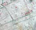
Rose Farm, Broadstone. Detail of from Ordnance Survey Sheet XLIII.4, 1:2500 scale, 1901 edition with valuation annotations.
Map