Showing results 6401 to 6410 of 6572
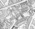
Extract from Borough Engineer's Plan 1952
Map
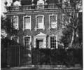
Museum Ref No: E1b_0008West End House, corner of Thames Street and West Street.
From the Ernest Bristowe collection.
Photograph
Museum Ref No: e1M_0011West End House, corner of Thames Street and West Street. frontage, picture captioned "West End House, Poole, Y.W.C.A."
Photograph
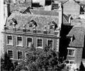
Museum Ref No: E1m_0009West End House, corner of Thames Street and West Street. Front of house and roof seen from above.
Photograph
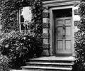
Museum Ref No: E1m_0008West End House, corner of Thames Street and West Street. Front door and steps. Frontage covered with foliage.
Photograph
Museum Ref No: E1m_0004West End House, corner of Thames Street and West Street. Frontage, first floor windows, parapet & attic windows.
Photograph
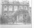
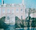
Museum Ref No: E1m_0001West End House, corner of Thames Street and West Street. Frontage viewed through front gates.
Photograph
Museum Ref No: E1m_0003West End House, Corner Thames Street and West Street. Frontage, first floor window, parapet & attic window.
Photograph
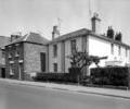
Museum Ref No: D_West_Quay_Road_0005West Quay Road, Nos.32-34. White building is Leon House. Photograph by Barbara Bristowe
Photograph
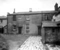
Museum Ref No: D_West_Quay_Road_0007West Quay Road. Yard at rear of old Wheat Sheaf Inn. Photograph by Barbara Bristowe
Photograph